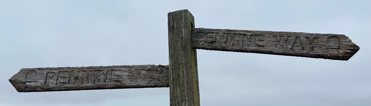

The Pennine Way is almost certainly the UK’s best known long distance path. Over our increasingly numerous weekend walks, we’ve done quite a few stages of it and I was beginning to think that perhaps I would ultimately like to walk it all in a single expedition. That opportunity seems quite a way off, however, so I continue to make do with ticking off various chunks of it. This time, we decided to do two stages across the Northumberland National Park. The northenmost stage of the trail is a mighty 25 miles, which is a bit hardcore, but the next two stages are slightly more manageable and also take in Hadrian’s Wall. We added a couple of much shorter walks each end, one as a warm-up and one to get us to the train station and the way home.
We had originally planned to start in Otterburn, mainly because it has accommodation, but we eventually decided to book a taxi minibus to take us ten miles up the road to the offical route and walk south from there, as the route from Otterburn to pick up the Pennine Way didn’t look that good.
To get to and from the walk, the group travelled to Newcastle by car or train and then we took a bus to Otterburn. At the end of the walk, we were able to catch a train from Haltwhistle station back to Newcastle.
- Day 1: Otterburn Village trail
- Day 2: Byrness to Bellingham
- Day 3: Bellingham to Once Brewed (inc a bit of Hadrian’s Wall)
- Day 4: Once Brewed to Haltwhistle
Friday - Otterburn Village Trail
- Distance: 3.2 miles
- Walking time: 1 hrs 30 mins
- Difficulty: Easy
- Accommodation: Butterchurn Guest House, Otterburn
- Dinner: The William De Percy, Otterburn
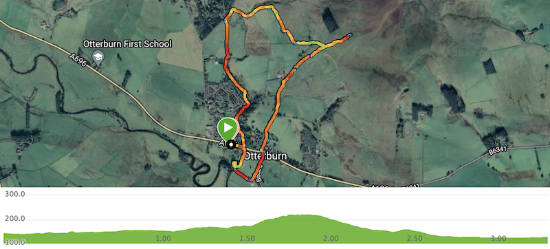
We reached Otterburn about 4pm and checked into the Butterchurn Guest House, where the owner gently made fun of us whilst rooms were allocated. Dinner was booked for 7pm, so we grabbed the chance to follow the Otterburn Village Trail. This leaves Otterburn northwards along the riverbank and then heads out towards the only nearby hill of note, Fawdon Hill. We took the detour to the top, where there are the remains of an iron age hillfort. It’s then an easy stroll downhill back into the village, which you pass through to get down the mill in order to follow the river back to the starting point.
We finished the day with a good pub meal at the William De Percy.
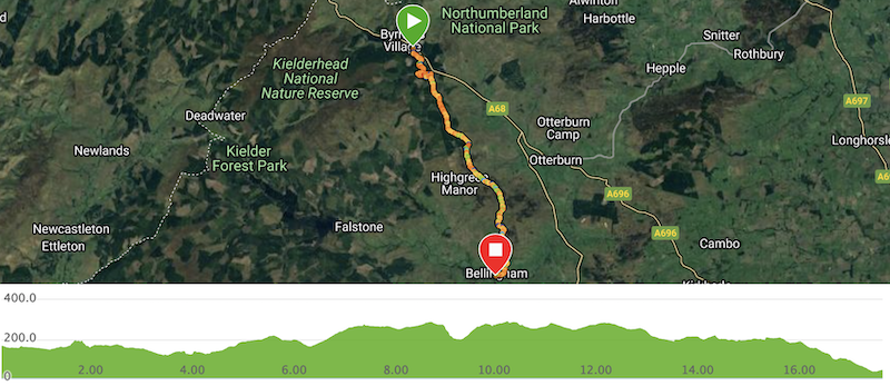
Saturday - Byrness to Bellingham
- Distance: 17.3 miles
- Walking time: 6 hrs 45 mins
- Difficulty: Tough
- Lunch: Packed lunch from the Border Reiver, store and cafe, Otterburn
- Accommodation: Cheviot Hotel, Bellingham
- Dinner: The Black Bull, Bellingham
The breakfast in the Butterchurn was most excellent. The lunch options in the local store, the Border Reiver, were somewhat less so. We gathered a selection of rubbish sandwiches and cheese and steak pasties, bolstered with crisps, and waited for the minibus to arrive.
It was a moderately pricey but useful twenty minute ride up the road to drop us at St Francis’ Church, where the Pennine Way heads south from the A68. We’d dropped a couple of our party a couple of miles earlier, to save them a few miles, as one was recovering from Covid and it was likely to be a long day.
A lot of this area is part of Kielder Forest. As a plantation, you will often pass through areas of it that have been harvested (it yields around 500,000 cubic metres of timber a year). This was the case of the area we soon reached, after we’d broken away from the Pennine Way in order to visit the Three Kings standing stones. We then had to meander along forest trails to pick up the Pennine Way again just before another detour took us to see Blakehopeburnhaugh waterfall. It’s quite a pretty spot, a long and thin cascade hidden within the trees.
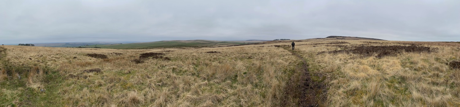
After a few miles of forest track, the route forks to the left and rises along a rocky path until suddenly the view opens up from Brownrigg Head. This is a remote spot and we soon passed ten miles into the walk, having seen neither road nor house and no more than a scant handful of other walkers.
The path rises and falls along moorland, some areas being notably more boggy than others. We finally caught up with our two walkers who had had the head start, but only because they’d paused for a leisurely lunch. They then had to wait whilst the rest of the group ate in the shelter of a large boulder before we headed onwards.
The path started to drop off the moor after about twelve miles, crossing the B6320 and passing along the edge of farmland. A final drop picked up the road into Bellingham (pronounced Belling-jam, we were advised). It’s a nice small town, although the Rose & Crown pub was a bit like the Slaughtered Lamb so we had a couple of pints in the Black Bull, where we also ate after checking into the Cheviot Hotel.
Dinner was rather sub-optimal. Bangers-and-mash was three or four chipolatas and a small pile of what someone suspected was Smash (on the other hand. the veggie option yielded six massive sausages, which was an interesting contrast) and all meals were accompanied by microwaved frozen veg. The staff were rushed off their feet, which might have explained it. At least the beer was good. We were chatting with the lady who served us breakfast in the Cheviot the next day and she exclaimed, “you went there?? For food??????”
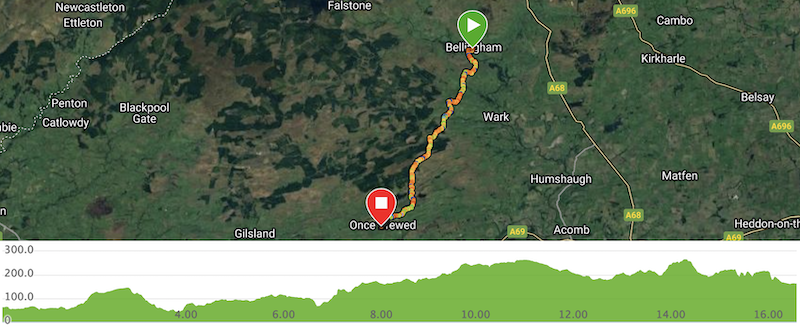
Sunday - Bellingham to Once Brewed
- Distance: 16.3 miles
- Walking time: 8 hrs
- Difficulty: Extremely tough
- Lunch: Packed lunch from the Co-op, Bellingham
- Accommodation: The Sill YHA, Once Brewed
- Dinner: Twice Brewed Inn, Once Brewed
A very comfortable night at the [Cheviot] and a huge breakfast, with marvellous service, made us wish we’d eaten there the night before. At least the local store (a Co-op) had a much more useful selection of items for a packed lunch than the Border Reiver had had.
The day started damp and barely improved. We’ve often remarked that we’ve been lucky with the weather on our weekend walks, one horrible sleet-lashed walk across Cross Fell notwithstanding. But our walk to Hadrian’s Wall was accompanied by light and persistent rain, to the extent that most of the party went for full waterproofs.
Leaving Bellingham along the river, the path briefly picked up the B6320 before turning south and climbing into farmland. Shortly after dropping down a crag, it passed by Shitlington Hall where the occupier grabbed one of our party to provide detailed descriptions of her many visions. Cutting a slightly tragic figure, she nevertheless demonstrated a remarkable ability to speak without ever drawing breath.
Overall, the main part of the walk was neither as remote nor splendid as the previous day. After rolling farmland, we passed into Kielder Forest again to discover that vast amounts had been removed following a levelling by Storm Arwen in late 2021. Acres and acres had been cleared and were quite desolate. The path was also very hard work, as the rains of March had put the majority of it underwater. This was particularly tough for two of our party, who had each discovered that their footwear was far from waterproof. They had my sympathy, as I remembered a sodden trudge off Pen-y-ghent, over a decade earlier.
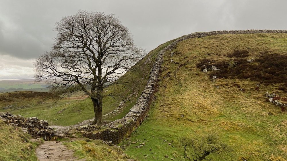
After Kielder, we crossed a couple of ridges as the path rose to meet Hadrian’s Wall. We turned west along the path next to the wall and I very much enjoyed following the ups and downs as it clung to the top of the ridge. Shortly after espying the tree made famous by Kevin Costner, after he and Morgan Freeman got lost on their way to Nottingham, we passed by the ruins of another Roman milecastle before some slightly slippery steps led us down to the road south to the marvellously-named Once Brewed where we’d booked rooms at the Sill YHA.
I’m not a big fan of YHAs as I think they’ve become too expensive and are often not comfortable enough. The Sill, however, is the cleanest and nicest I’ve ever stayed in (helped by it only having opened in 2018). Even better, the Twice Brewed Inn just down the road served good food (admittedly a little pricey) and has a micro-brewery attached, with top-notch beer. Booking was essential, however, as it was rammed.
Monday - Once Brewed to Haltwhistle
- Distance: 5 miles
- Walking time: 2 hrs
- Difficulty: Medium
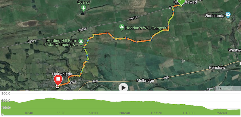
After a pretty standard YHA breakfast, we found that Monday was much brighter than the day before and even gave us a bit of sunshine for the relatively-straightforward stroll into Haltwhistle. It mainly passed through farmland and was generally very pretty and uneventful. We somehow failed to navigate through Haltwhistle itself, instead finding ourselves walking along the main road to the south for the last mile to the station. But we were thankful to find a couple of benches on the platform to rest our feet and await the train back to Newcastle.