
The North Downs Way runs for a hundred and fifty miles from Farnham in Surrey to the White Cliffs of Dover. We originally chose to walk part of it just after the coronavirus lockdown as we wanted something relatively close that could be cancelled if things got bad again. In the end there were no disruptions and we enjoyed the first two days so much that we decided to walk another weekend a year later (both are presented here, as I forgot to write up the first weekend at the time!). As with our South Downs Way walk, the route is well-served by public transport and most of the group took the train to and from the walk.
Re-reading this blog post, it seems to focus a lot on the hostelries we found along the way. This isn’t to diminish what a nice walk the North Downs Way is but instead reflects how well-signposted it is, as directions and maps were almost never required.
- Day 1: Farnham to Guildford
- Day 2: Guildford to Dorking
- Day 3: Dorking to Redhill
- Day 4: Redhill to Oxted
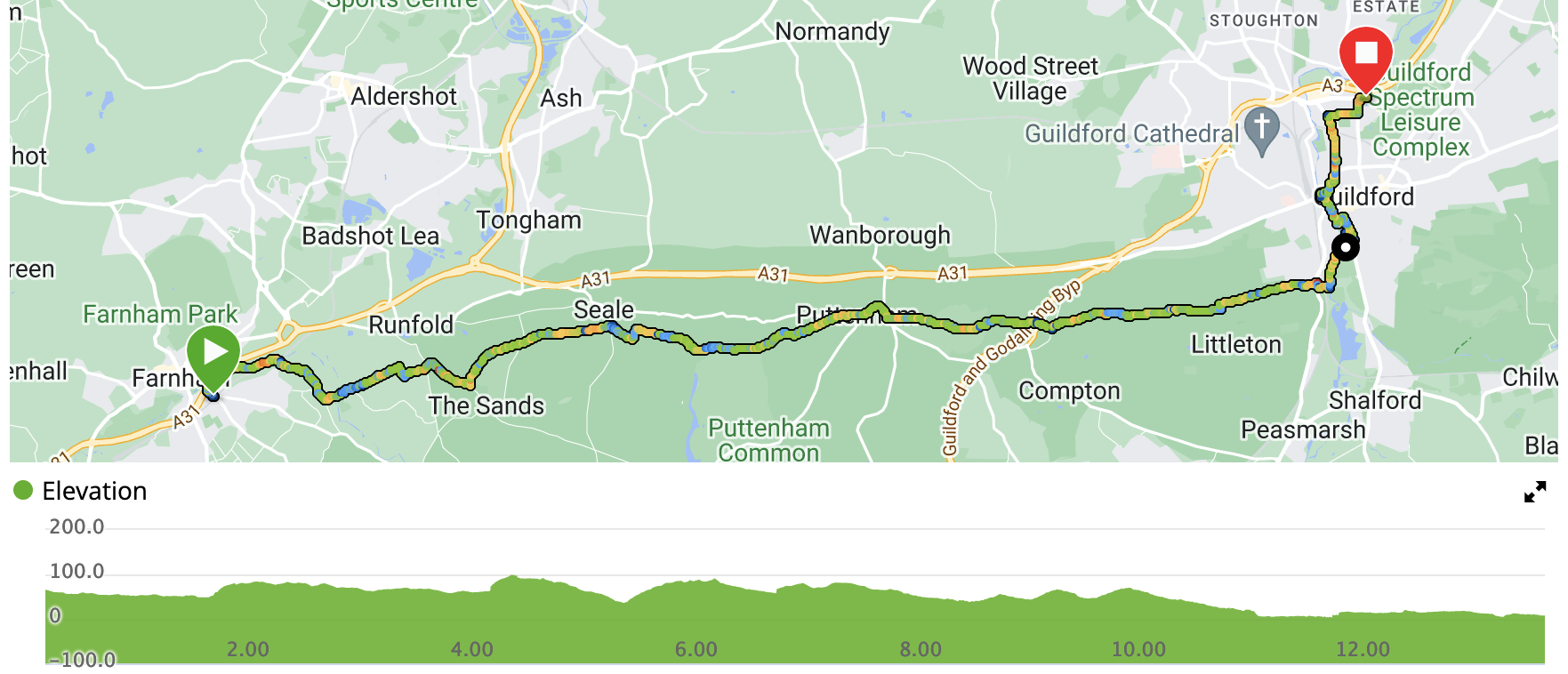
Weekend 1 Saturday - Farnham to Guildford
- Distance: 13.5 miles
- Walking time: 4 hrs 45 mins
- Difficulty: Medium
- Lunch: The Good Intent, Puttenham
- Accommodation: Premier Inn, Guildford
- Dinner: Nuro, Guildford
The night before the walk, we stayed in the Premier Inn in Aldershot, as it was quite a bit cheaper than staying in Farnham. We had a rather nice Indonesian meal in a tiny cafe/restaurant called Waroeng Windsor. He can’t seat more than about fifteen people and had stayed open for us but it seemed very worthwhile on both sides, even though each time he recommended a dish and we said we’d order it, he’d say “sorry, I don’t have any!” We then went to watch a band and have a couple of pints round the corner in the Trafalgar Inn.
In the morning, we were shuttled the few miles south to Farnham station by a member of the group who had chosen to drive (he’d later catch the train back from Guildford). A taxi wouldn’t have been expensive, though.
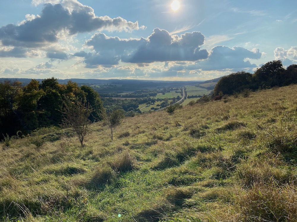
Very shortly after leaving the station forecourt, there is a sign that marks the official start of the walk. Just a few yards further on, the path turns into woodland and very quickly we felt that we’d left the town behind. This section of the walk was a bit twisty-turny as it initially wended its way along the River Wey, crossed a few roads and skirted some of the estates around Farnham. Once we were 90mins out of Farnham, we really felt that we’d found the start of the ridge as farmland rolled away to the north.
We soon dropped into Puttenham, where we had a table booked at The Good Intent. I’d chosen it as it had a good varied menu including sandwiches and salads and I thought we might not be too hungry, as it wasn’t too far into the walk. As a result, everyone in the group ignored those options and had a full meal…
Once lunch was out of the way, we crossed the B3000, which is a cut-through from the A31 to the A3 and often quite busy. It didn’t trouble us, though, so we carried on, under the A3, and then the path left roads behind and, staying just outside woodland, we walked uneventfully along the edges of fields.
Before we knew it, we’d reached the River Wey again, which had meandered south of us for many more miles than we’d walked and was now quite a decent size. We walked along its banks to get into Guildford. As the remainder of the day’s walk was across Guildford, we decided to refresh ourselves in The Weyside before heading into town. Leaving one of our group to catch the train back to Farnham and his car, we dropped our bags in the Premier Inn and went to meet a friend and have kebabs for dinner in Nuro.
Following dinner, with a local tip-off, we ended up in The Three Pigeons, which was the pub of the weekend and well-recommended. In fact, I struggled to tear myself away, despite the weariness in my fellow walkers’ eyes.
Weekend 1 Sunday - Guildford to Dorking
- Distance: 16.5 miles
- Walking time: 6 hrs 15 mins
- Difficulty: Tough
- Lunch: The Dabbling Duck, Shere
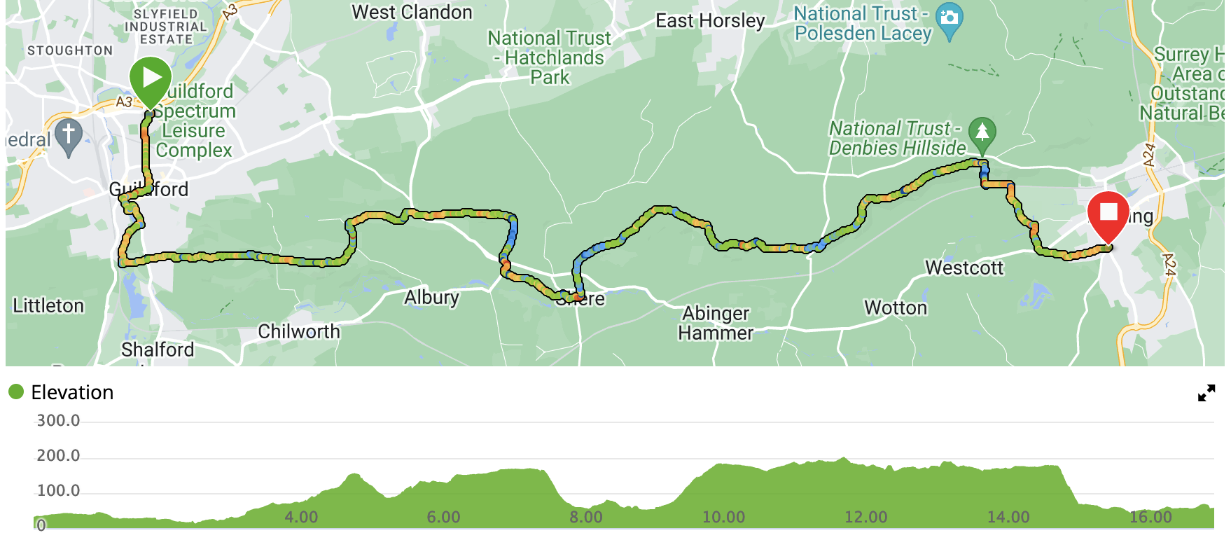
Day one of the North Downs Way was nice but not too disimilar to walking around my home in Ampthill. Day two, however, was an absolute treat. The route stays up on the ridge (except where we dropped down into Shere for lunch) and feels completely away from London and its environs, despite being just a few miles from the M25.
First of all, however, we had to cross Guildford again to pick up the river and get back to where we’d left the official path the day before. After 90mins, we’d climbed up onto the ridge and reached St Martha’s church, which has a prominent position albeit seemingly a long way from any congregation. The route then stays in wonderful mixed woodland, dropping down a bit before climbing again.
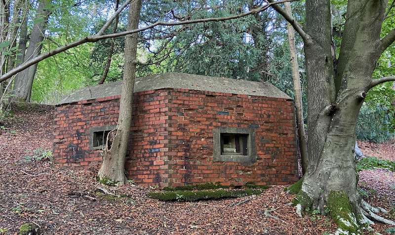
Seven miles after setting off, we dropped off the ridge to get to The Dabbling Duck in Shere where, in contrast to the day before, appetites were sated by a pleasant selection of sandwiches. It was then a bit of a slog to get back up onto the official route via a rocky track. This then continued to be within woodland but was increasingly punctuated by pill boxes. These are the remnants of World War II fortifications to keep the Germans out of London (had they chosen to invade from the south rather than just sail up the Thames, presumably).
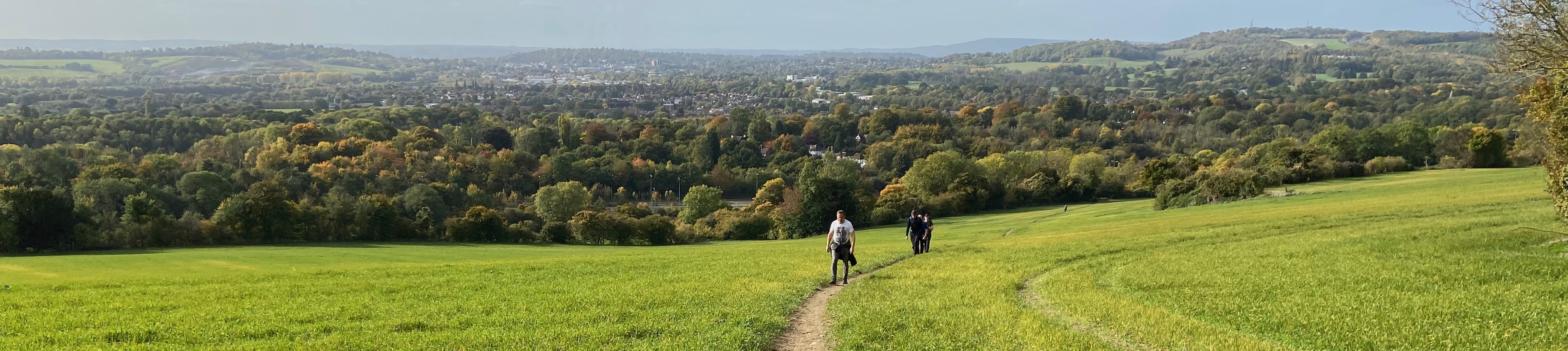
The views began to open out to the south and were frequently rather lovely. After a couple of hours, we could see Dorking nestling below. We dropped steeply off the ridge to cross a railway line and then make our way across town to The Queens Head where we put our feet up before heading to the station and the train home.
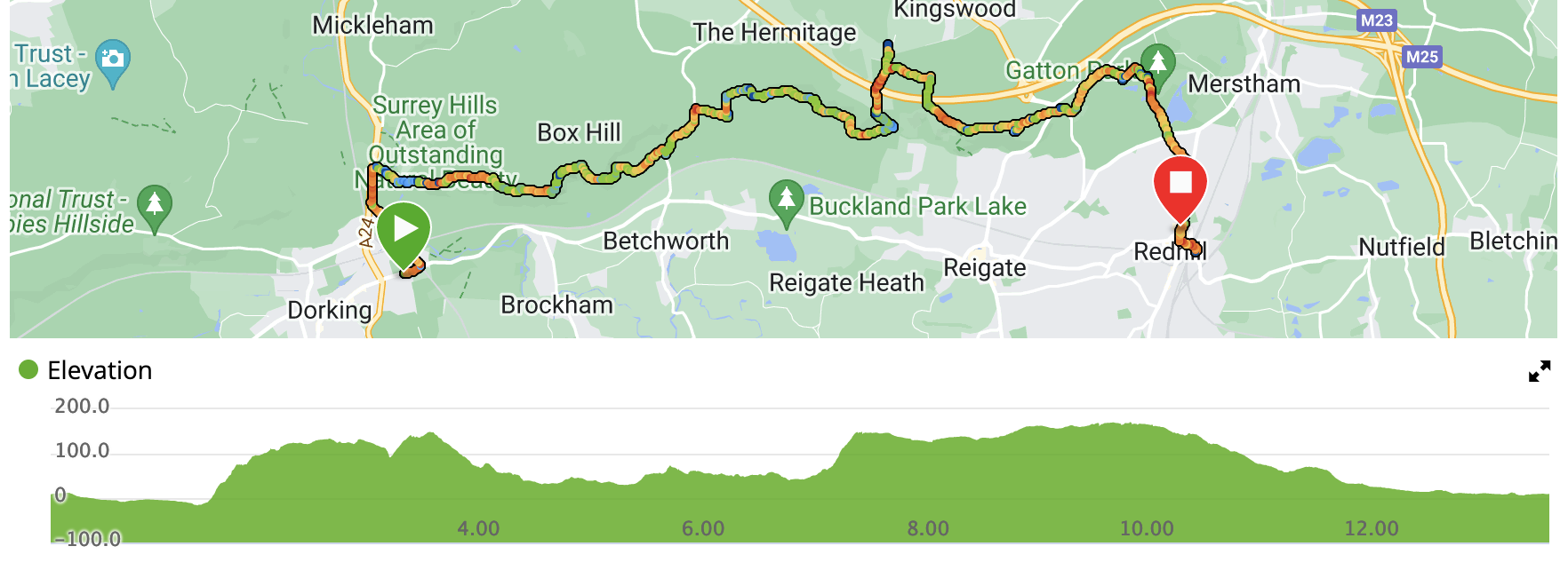
Weekend 2 Saturday - Dorking to Redhill
- Distance: 13.5 miles
- Walking time: 5 hrs 15 mins
- Difficulty: Fairly tough
- Lunch: The Sportsman, Mogador
- Accommodation: Travelodge, Redhill
- Dinner: Home Cottage, Redhill
The night before the walk, once again the convenience of the hotel chain won through and we stayed in the Travelodge in Dorking. We ate some solid pub food in The Old House, tried out a couple of other pubs in town and then headed back to the hotel. The next morning, we eschewed the yoghurt and long-life croissants on offer in the hotel and instead had a full English in Peppe’s Cafe.
Having dropped off the ridge west of town at the end of the previous weekend, we missed a small chunk of the official path by walking along a bit of the A24 to pick up the North Downs Way at the foot of Box Hill. Here we crossed the River Mole via some stepping stones to reach the start of the steps up the hill. Quite a stiff endeavour so soon after breakfast and, although not in the same league as Lakeland walking, there was still some huffing and puffing up to the top. We’d just missed the morning mist, but a dog walker stopped us to share his amazing photos of the mist covering Dorking with blue sky above. After this, the walk was very similar to the previous section, which was most welcome. There are a couple of derelict limeworks along the route, and their chimneys would suddenly poke out of the trees below us.
After seven miles, we left the route to cross the M25 into Mogador where lunch was at The Sportsman. Fed and watered, we picked up a path back over the motorway and back onto the Way. We explored Reigate Fort as we passed by - this being a fortification built in the 19th century to keep the French at bay, had they also chosen to attack London from the south rather than sail up the Thames.
After the fort, the path was much better laid and busier. It also felt much less remote than before. We elected to swing into Redhill via the grounds of Gatton Hall and the Royal Albert and Alexandra school, having admired the Millenium Stones just beforehand. We then found ourselves in Redhill and had some fun working out which of the two Travelodges we had booked by walking to each in turn.
To be frank, Redhill was not the prettiest place we’d visited on the walk and dinner in Home Cottage was so-so. After dinner, however, we found ourselves playing bar billiards and darts for a couple of hours in The Garland, where they also served an excellent range of Harvey’s beers.
Weekend 2 Sunday - Redhill to Oxted
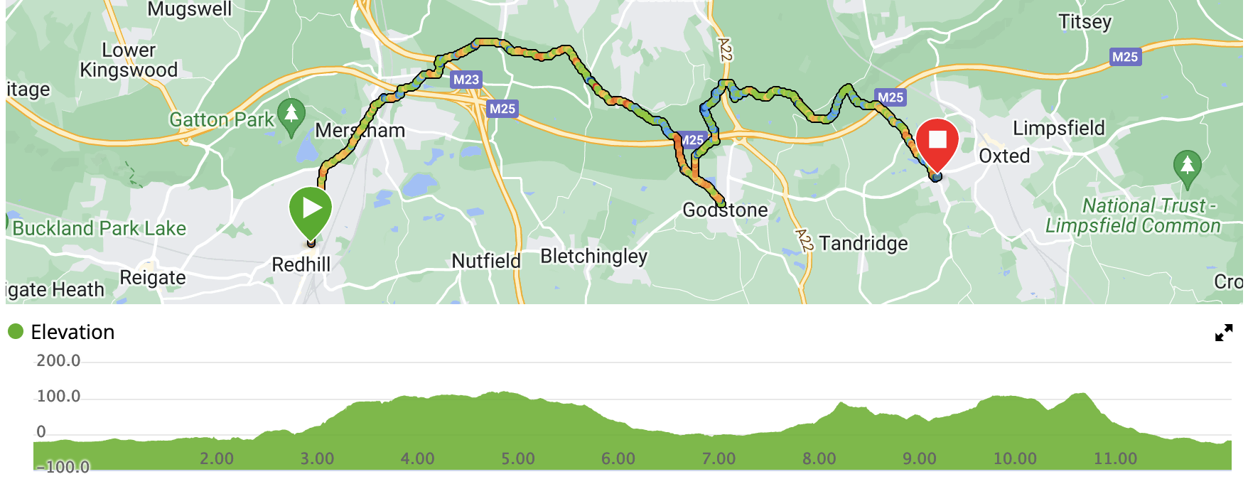
- Distance: 12 miles
- Walking time: 4 hrs 15 mins
- Difficulty: Medium
- Lunch: The Hare and Hounds, Godstone
Breakfast was served in the hotel and we then headed north again. There was a slightly tedious urban walk for a couple of miles to Merstham station and then over the M25 before the path rose to give good views back to the countryside around Redhill. We then crossed the M23 and the walk varied between farmland, meadows and woods for three more miles or so. We again left the Way to pop into Godstone for a quick bite to eat in The Hare and Hounds, where the barman encouraged us to complain about the (entirely acceptable) food as he “enjoys giving bad news to the chef”.
The next section was wooded and contained the only bit of the route where we missed the signs and lost the path for a couple of hundred meters. This was in a pleasant country lane, which was ruined by the amount of flytipping going on - even whilst we were passing. Scumbags.
After a while, the path began to be on country roads more than tracks and we found ourselves in Old Oxted, which had a lovely selection of pubs from which we randomly chose The George for our end-of-walk drink. It was then a mile or so to the station and the train home.